HISTORY OF THE REGION
Karapınar is our nice county where belongs to Konya, whose area is 2675 km2 and population is 42259 and where has historical richness. It was established by Pro-Hittites and Hittites in BC 2000. It was named by Selim II as Sultaniye, became a county in 1868 and gave the name Karapınar in 1934. The country located on the state highway between Adana and Konya and at Konya plain is covered by Karacadağ from east, Andıklı, Küçüktartan and Büyüktartan hills from South.
Four large soil groups (alluvial, colluvial, sierozem and regosel) are seen in their fields. In the fields where wind erosion is observed, soil texture is generally thin (loamy sand)in topsoil and also has a heavy (clay) structure in the depth of profile. The soil is rich in lime and potash and very poor in organic material and phosphor.
As the agricultural field is of 1 595 000 decare, it has a destruction originated from wind erosion in a section of 1 030 000 decare. In Karapınar that earns a livelihood with field agriculture and stockbreeding, irrigated farming became active with deep pits which are digged in the end of fighting works against wind erosion which started in 1962 and a field of approximately450 000 decare becomes irrigated today.
The region has dry and terrestrial climate feature. Annual average rain is 275 mm, average temperature is 11 °C and dominant wind direction is North-Northeast. Annual average wind speed is 3.5 m/s'. Effective winds in erosion blow from South-Southwest. Sometimes, the speed of wind goes up to 110 km/h.
EMERGENCE OF WIND EROSION
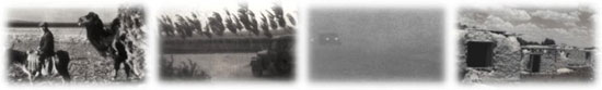
Karapınar faced the danger of migration because of violent wind erosion in 1960s.
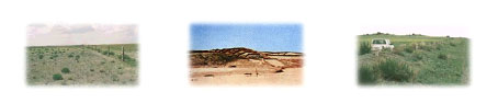
In the county where has a land dune of 43 000 decare, dune hills rose after dunes are run by wind, dust clouds were created and agricultural fields faced with the danger of losing its yield. Sand storms began to cause financial losses and machines became disabled. The region's public couldn't send their children to school and respiratory tract diseases originated from dust and sand storms started emerging. Sand clouds originated from wind affected traffic in the Konya-Adana highway negatively and caused that the highway was sometimes closed. These negative condition forced the region's public to completely immigrate and abandon Karapınar and their homes.
The Reasons for Wind Erosion in Karapınar
The fact that the region of Karapınar is an old lake bed and dunes at the bottom of it rise to the surface because of drying of the lake over time (The fact that there are sea shells somewhere in the dunes approves this thought),
The fact that the region is very highly dry and hot in terms of climate (Annual rain is around 260-280 mm, annual average temperature is around 11-12 °C),
Destruction of pastures in the end of bottom and heavy pasturage because of the widespread structure of sheep and goat farming in the region in particular,
Destruction of pastures as a result of removing some plants (milk vetch, tapir, mullein etc) which is not consumed by animals in pastures, but hold soilwith the region public's aim of using as fuel,
The use of such vehicles as diskharrow which harrows soil with shock-disk plows by fully overturning soil in the agriculture of fallow-cereal,
The fact that fields are on effective wind belt.
The situation originated from the combination of such these bad factors in the county didn't discourage the county's public and they looked for the ways to get rid of erosion. Under the leadership of governance of Karapınar, the issue was said to public institutions and solutions were searched.
FIGHT AGAINST WIND EROSION
Fight against wind erosion in Karapınar was started by General Directorate of TOPRAKSU, one of the institutions composing General Directorate of Rural Services in 1962.
A field of 160 000 decare is hedged in the first step and preventive works start for erosion in this field. Works in the region have been continued uninterruptedly so far. Today, protection, control, production and research works are done by the Research Institute Directorate of Rural Services under the name of Research-Secondary Station of Rural Services in an area of 130 000 decare.
Works Conducted by General Directorate of Rural Services in Troubled Fields
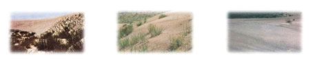
Field of Sandbars (43 000 decare)
Rehabilitation works are done on the field where primary erosion effect is observed, located at 7 km-away Southeastern Karapınar and of 43 000 decare. This field properly appeared to be a desert and there was no any floras. Crescent dune hills emerged in the height of 40-45 m, the width of 50-60 m and the length of 250-300 m. Dunes, which are even affected by the lightest wind movements, threatened the Karapınar county by crossing over Ketir Hill where is of 15 000 decare and covered by basaltic rocks when strong winds blow. First of all, it is thought to bring this field under control and rehabilitate and a two-steps work is conducted:
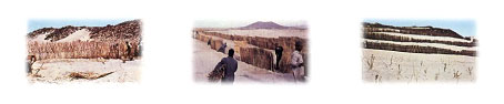
1. Physical Measures (the facility of nutgrass sheet) :Nutgrass sheets are first facilitated to interrupt the speed of wind and prevent the movement of it on dune hills with the lack of flora and moving with the effect of wind. Nutgrass sheets are facilitated in the height of 1.5-2.0 m as perpendicular to dominant wind direction and with a 12-20 m (8-10 times more height of sheet) distance between two sheets. A two-row fence is put around the sheets as there is 40 cm from bottom side and upside and they are fixed by trenails in every two meters while determining field.
2. Cultural Measures
a.) Grassing :After the speed of wind is partially decreased by nutgrass sheets created on dune hills and the movement of sand is stopped, between the sheets is begun to be grassed. Here the aim is to close soil surface very well and completely stop the movement of sand. In these works, with weed seeds collected by the local pastures, such culture plants as sand rye that is hot and dry-resistant (Scale sp.), crested wheatgrass (Agropyron cristatum) and high crested wheatgrass (Agropyron elongatum) are widely used.
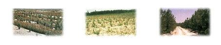
b.) Forestation :After between the sheets is grassed, forestation workings started as the permanent measure in order to completely stop the movement of soil. Elaeagnus, acacia, ash tree, witch elm and acer types which are exclusive to the region and resistant to drought are used in forestation works.
Running Sand Field (40 000 decare)
It is known that his field was a very quality pasture in the previous times. Because of such reasons as wrong use of pastures, overgrazing, removing some plants in the form of brier as firing, turning pastures into fields, not using field according to its capabilities and the use of wrong tillage vehicles, this field falls into ruin and becomes open to erosion.
The field under this circumstance is first hedged within the scope of rehabilitation works and when the impact of animals and humans is removed, current plants naturally reproduced and the surface of soil is covered by new plants and the effect of erosion is removed.
Flat Terrains Sensitive to Erosion (32 000 decare)
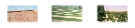
This field is agricultural terrains where don't have any floras, were exposed to dry agriculture, but abandoned because of erosion. When preventive works for erosion was successful in a section of 10 000 decare in the region, the region's public came back to their territory and started agriculture under the control of Konya Research Institute of Rural Services.
In the other section of this field of 20 000 decare, agriculture is done with the method of Fallow-cereal band seeding in the size of 40-60 m as perpendicular to prevailing wind. In the field of 2 000 decare, fruit and seedling growing are done with the aim of demonstration.
Ketir Hill Field (15 000 decare)
It is a closed field where covers from the Southwestern county to sand dunes, is of 15 000 decare and covered by basaltic rocks. In this region where is called covered by trees beforehand, there was no even one tree by the time the rehabilitation works started.
Along with soil conservation works, natural flora is stimulated again when soil move is stopped and such plants as whin, andromeda almond and blackberry come. Furthermore, numerous pines and cedars are planted with 700 000 almond trees on the hill foot. During the works.

TODAY OF KARAPINAR
Desertification and Erosion Research Center of the Institute Directorate of Soil, Water and Combating Desertification of General Directorate of Agricultural Researches and Policies, Ministry of Food, Agriculture and Livestock, continues its rehabilitation works on the region and protection, control, production and research studies.
Studies which still continue at our centre are as the following:
With the method of fallow-cereal band seeding, an area of 20 000 decare is both protected from erosion and has agricultural production.
The field of 15 000 decare where is covered by basaltic rocks, pasture and such coniferous trees as pine and cedar are planted every year. 700 000 almond trees which are planted on the Ketir hill are maintained.
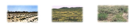
The area of 43 000 decare where is composed of sand dunes becomes a jungle with planting works. In that field, such maintenance processes as struggling pests and pruning are realized and new young trees are planted every year.
The area of 40 000 decare where is under protection is pasture and completely covered by flora.
In an area of 10 000 decare where is located within the region under protection and is a field belonging to the locals, agriculture is one under control of our Institute.
With the opened boreholes, vineyards and orchards are created by presenting an area of 6000 decare. In these fields, such fruit types as apple, pear, apricot, cherry, greengage plum and such vegetables as onion, bean, tomatoes, and pepper are grown up as demonstrative.
In addition to them, research projects about refreshing aged trees and the region within the scope of the Institute are still realized in this field.
After bringing erosion under control, agriculture-based economic action is created in the region. Karapınar starts forgetting its bad days in the past and looking at the future confidently. It celebrates getting rid of bad news in the past and erosion as "Soil Festival" internationally in June every year and aims at handing the past events, studies which have been done and success which has been gained down the next generations.
Karapınar waits its new visitors as a successful example of the cooperation between state-citizen and social participation in the solution of problems with the happiness of getting rid of erosion.